
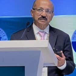
Prasad S. Thenkabail, Ph.D., is a Senior Scientist (ST) with the U.S. Geological Survey and one of the world’s most influential authorities in remote sensing, global agricultural monitoring, and hyperspectral imaging. Over a distinguished career spanning more than four decades, he has produced foundational scientific contributions that have transformed how the world maps croplands, assesses water use, and applies satellite data to food‑security challenges. His pioneering work led to the development of the world’s first 30‑meter Global Cropland Extent Product (GCEP30) and the Landsat‑based Global Rainfed and Irrigated Area Product (LGRIP30), both of which set new global standards for spatial detail, methodological rigor, and scientific transparency. These products are widely used by governments, research institutions, and international development agencies working to address food and water security.
Dr. Thenkabail has played major leadership roles in NASA’s Global Food Security‑Support Analysis Data (GFSAD) program, advancing petabyte‑scale analytics using Landsat, Sentinel, PlanetScope, and cloud‑computing platforms such as Google Earth Engine. His work integrates multisensor time‑series imagery with artificial intelligence, machine learning, and deep learning to produce global agricultural products at unprecedented spatial resolutions. He is internationally recognized for his expertise in hyperspectral narrowband imaging, optimal band selection, and vegetation indices, and his research has shaped modern approaches to full‑spectrum analysis and satellite‑based crop characterization. His scientific achievements were honored with the 2025 ASPRS Outstanding Technical Achievement Award, reflecting his sustained contributions to advancing remote sensing science.
As Editor‑in‑Chief of Remote Sensing, one of the largest and most influential journals in the field, Dr. Thenkabail has helped guide the direction of global EO research and uphold rigorous scientific standards. He has edited 15 major books, including the landmark six‑volume Remote Sensing Handbook, a comprehensive reference used worldwide by researchers, practitioners, and students. His editorial leadership has strengthened scientific communication, expanded interdisciplinary collaboration, and elevated the visibility of remote sensing research across environmental science, agriculture, hydrology, and climate studies.
Ranked among the world’s top 1% of scientists, Dr. Thenkabail has authored more than 202 peer‑reviewed publications with over 19,600 citations, demonstrating the global reach and enduring influence of his scholarship. His work is frequently cited in studies on agricultural monitoring, water‑use science, hyperspectral analysis, and satellite mission design. His career includes extensive fieldwork across 28 countries, where he has conducted on‑the‑ground assessments of agricultural systems, water resources, and environmental conditions. These field campaigns have provided critical validation data for satellite‑based models and have strengthened the scientific foundations of global cropland mapping.
Dr. Thenkabail has served on the Landsat Science Team and has played leadership roles within NASA’s Surface Biology and Geology (SBG) Applications Group, contributing to the design and application of next‑generation satellite missions. His insights have helped shape mission requirements, spectral band selection, and application priorities for future hyperspectral and multispectral sensors. His work continues to influence how satellite missions are conceptualized, ensuring that they meet the needs of global agriculture, water‑resource management, and environmental sustainability.
Beyond his scientific achievements, Dr. Thenkabail is widely respected for his mentorship, leadership, and commitment to building global scientific capacity. He has trained and collaborated with researchers across Asia, Africa, Europe, and the Americas, fostering international partnerships that advance EO science and support global food‑security initiatives. His lectures, workshops, and invited talks have inspired a generation of scientists working at the intersection of satellite data, agriculture, and water resources.
Dr. Thenkabail’s work continues to define the frontier of global agricultural monitoring, water‑use science, and Earth observation. His leadership, scientific vision, and dedication to advancing satellite‑based understanding of the planet have made him one of the most respected and influential figures in the remote sensing community worldwide. His contributions provide critical tools and insights for addressing some of humanity’s most pressing challenges, including food security, water scarcity, climate resilience, and sustainable resource management.