February 23-25, 2027   |  Salt Palace  |  Salt Lake City, UT, USA

2027 Keynote Presentations

Nearmap

A Lake in Crisis:
Mapping Utah's Great Salt Lake

Wednesday, February 24, 2027 | 2:00 PM

"The Great Salt Lake is Local to Utah. Its Importance is Not."

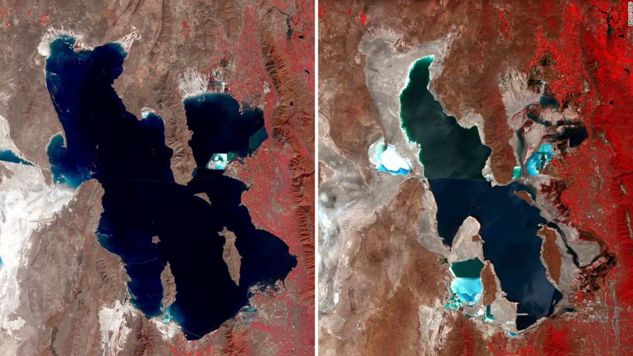
The Great Salt Lake is shrinking, and that’s a problem for everyone in Utah — its waters and wetlands support millions of migratory birds, its brine shrimp feed a global aquaculture industry, and its exposed lakebed can kick up dust that sweeps into nearby population centers. As water levels change, understanding exactly what’s happening beneath the surface has never mattered more.

This session tells the story of an ambitious effort to map that hidden world. The Utah Geological Survey, Aero-Graphics, and Dewberry are collaborating on a large-scale bathymetric lidar project to map shallow lakebed, wetlands, and deeper-water environments across portions of the Great Salt Lake. The work combines Utah-based aerial acquisition, green-wavelength bathymetric lidar, multi-sensor planning, and advanced processing to improve on legacy datasets and reveal details of the lakebed that have long been difficult to see. It’s a technically demanding inland bathymetric lidar effort, complicated by murky water, shifting shorelines, and a lake that’s constantly changing shape.

The session will begin with why the lake’s decline matters: who is impacted, what’s at risk, and why better lakebed information is essential for science, management, and public decision-making. It will then move into the geospatial challenge of collecting data in a dynamic lake environment. Finally, Utah Geological Survey will share what the new data is revealing about microbialite reef structures, lakebed morphology, wetlands, geologic features, and future research needs. As Geo Week comes to Salt Lake City, this session invites attendees to look beneath the surface of one of the West’s most iconic — and most threatened — lakes and see how better data can help communities respond.

Kelly Francis
Session Moderator
Co-President, Aero-Graphics
Mr. Francis has over 35 years of drafting, surveying, cartography, project management, and executive experience with Aero-Graphics and is currently a Managing Partner of the company, providing executive leadership, front-office management, and oversight of senior staff. Through the years, Mr. Francis has successfully executed and managed numerous aerial survey projects for a wide array of clientele, including federal & state agencies and various private enterprises throughout the country. In addition, he has served as MAPPS President and been an active participant in MAPPS Capitol Hill lobbying efforts since 2012, which support funding for 3DEP and other geospatial initiatives.
Bonnie Baxter
Director, Great Salt Lake Institute, Westminster College
Dr. Baxter studies the photobiology of halophiles (salt-tolerant bacteria) and microbial diversity of Great Salt Lake (GSL)with her undergraduate students. She is interested in the astrobiology applications of extremely hypersaline ecosystems, in particular resistance to ultraviolet light and desiccation by halophiles. Recently her students have been engaged in projects involving ancient biomolecules in salt, microbial composition of GSL stromatolites, and lake microbial mercury methylation. Dr. Baxter is also dedicated to integration of research in undergraduate science education and to outreach efforts that inspire learning and stewardship. She is also engaged in efforts to support underrepresented groups in STEM fields. All of these interests merge in her role as Director of the Great Salt Lake Institute.
Josh Novac
Associate Vice President, Program Manager, Dewberry
Josh specializes in GIS, photogrammetry, and Lidar. As a program manager he provides oversight on projects for USGS and as one of our remote sensing technical experts, he provides guidance on project requirements and helps identify the most efficient approach to executing the project. This includes identifying subcontractors to perform the work, and aiding in the management of subcontractors to ensure projects are acquired and processed to the required specifications. His work on process improvement helped reduce Lidar processing costs through his development of new automated tools and processes to efficiently extract additional information from Lidar data, including buildings and vegetation.
Michael Vanden Berg
Energy & Minerals Program Manager, Utah Geological Survey
Michael Vanden Berg is the UGS Energy & Minerals Program Manager, leading a diverse team of geoscientists that research Utah’s energy and mineral resources. His main area of research focuses on the petroleumbearing lacustrine Green River Formation in the Uinta Basin. He is also involved in research on the modern Great Salt Lake, including its extensive microbialites, as an analogue for ancient lacustrine deposits.

(USGS EROS imagery comparing the Great Salt Lake in 1987 and 2022)

Stay tuned for more keynote information to be announced!